
As Craig explained, three of us went down and learned the basics of the ArcGIS software. Although we are not quite settled on the details, we decided that while we have this state-of-the-art software within our grasp, we should make two maps: one of Houston and one of the Sabine Pass site.
For both maps, we plan to mark pinpoints relevant to both Dowling’s life and the impact he has left through posthumous memorials. It occurs to me now that we could perhaps make these as two separate layers on the maps, or perhaps do them in different colors. So instead of looking at the map and seeing a confused jumble of pinpoints, you could toggle layers or pick out certain colors, and view only the footprints that Dowling himself left, OR the various memorials to him.
After looking at the Sabine Pass area, we realized we knew little about it, from the actual geography of the battle to the layout of the area today. So I took it upon myself to look further into it.
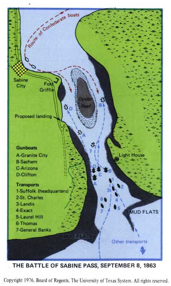
To start off, I found a map from the University of Texas Library that should help us get a better mental image of the battle itself.
As for the battleground today, it is now a historical site: here is its official website. It is quite a low-key historical site; I took a browse using the embedded Google map here and, to be honest, it seems like a whole lot of nothing. There is no visitor’s center or any place to buy refreshments. I couldn’t find an actual map of the park, and even poking around on the Google satellite imagery, couldn’t locate the monument statue and “interpretive pavilion” that are supposed to be there.
If anyone can help me locate where these memorials are placed, that would be great. Right now, I feel like I’m flailing around in the dark!
I think I found the Pavilion and the statue using Google maps! It takes a little searching but the statue is in a secluded section of the park, in the southern portion. If you look at the picture of the statue on the battleground webpage you can see a industrial complex and oil rig in the background. To find the statue I located the complex on the LA side of the river and drew a line to the park. the statue is off a ways to the South from the parking Lot standing alone. it appears to be circled by a sidewalk or a running trail. Also the pavilion (or what I’m guessing it is) looks like a white gazebo directly south of the parking lot. I hope this helps you. To me the battle ground appears to be utilized more for the boat ramps north of the parking lot, its sad that this historic site is so underutilized. Let me know what needs to be done next.
I agree that we definitely want to have one layer of our Houston map contain memorials to Dowling’s life. However, Dr. McDaniel mentioned that we might want to expand our criteria. Do you think we should consider including other Civil War memorials that are in Houston like at St. Vincent’s Cemetery and memorials that the Daughters of the Confederacy have erected? Or should we keep our criteria exclusive to Dowling?
I would like to keep the map of Houston centered around Dick Dowling and the Battle of Sabine Pass. If we include ALL Civil War memory, the map would be really crowded. I like the color coordination idea. Perhaps we can use different types of markers to signify time period or somehow use the visuals to show chronology and categories. What about landmarks around the statue? ie City Hall in 1905? I think that could give perspective to these maps.
I think what Dr. McDaniel suggested was not all Civil War memorials; but rather, he said that there are a few memorials to the battle of Sabine Pass which aren’t specifically about Dowling. I think we should consider including those, because Dowling and the battle are inseparably linked. For instance, I remember reading somewhere about a monument to the Union soldiers of the battle…?
I really like the idea of adding landmarks, Craig. We don’t have to recreate the whole city in an earlier age, but if we could pick some important buildings and locations, it would be a lot better than just having, say, the Bank of Bacchus or Dowling’s original statue location floating around as a spot on the map without any context of what the city was like at the time.
Thanks a ton, Ross! We can overlay those memorials on top of our battle map. Indeed, now that we’ve found them, recreating the site today won’t be a challenge… because there’s hardly anything there!
If you’re interested in providing context about the city of Houston at the time (i.e., where was City Hall, what else was in the area), you may want to read Jaclyn’s post, which could point you to some historical maps of Houston that the GIS/Data Center might be able to layer onto your map.